Many areas in the country are seen to experience rains and strong winds, as Severe Tropical Storm Marce moves slowly.
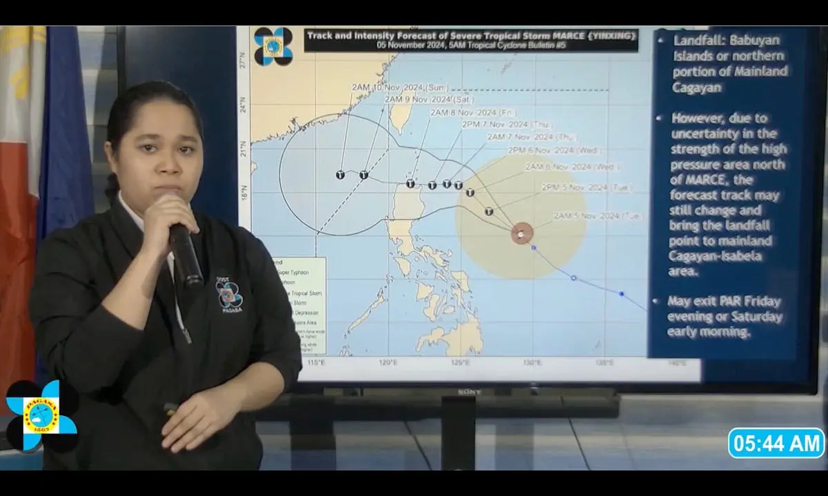 Philippine Atmospheric, Geophysical and Astronomical Services Administration weather specialist Rhea Torres gives an update on now Severe Tropical Storm Marce Tuesday, Nov. 5, 2024.
Tropical Storm Marce has intensified into severe tropical storm and is nearing typhoon category, according to the Philippine Atmospheric, Geophysical and Astronomical Services Administration.
In an advisory issued at 5 a.m. today, Nov. 5, PAGASA said the center of Marce was at 735 kilometers east of Baler, Aurora with a maximum sustained winds of 110 kilometers per hour and gustiness of up to 135 kph.
PAGASA weather specialist Rhea Torres said Marce may make landfall in the vicinity of Babuyan Islands or mainland northern Cagayan.
Many areas in the country are seen to experience rains and strong winds, as Marce moves slowly.
PAGASA Weather Division officer-in-charge Christopher Perez said heavy to intense rains should be expected beginning Friday until weekend in the affected areas.
“We will start to issue a weather advisory on the rainfall scenario beginning Tuesday,” Perez said.
“Gusty winds may be experienced in Aurora, Quezon, Camarines Norte, and some parts of the Southern Luzon area,” he said.
Even areas not covered by storm signals will experience light to moderate rains, according to Perez.
“Regardless of the characteristics of a typhoon, we need to prepare, especially that Marce may reach typhoon category before it approaches Northern Luzon. Based on the forecast track, starting Wednesday (Nov. 6) we will experience rains and gusty winds, especially the western side of Northern and Central Luzon,” he added.
PAGASA deputy administrator for operations and services OIC Juanito Galang said Marce’s impact can be felt as early as Thursday, Nov. 7.
“Based on the forecast track of the typhoon, before it makes landfall, storm surge is expected in portions of Cagayan. We should expect the effect of Marce as early as Thursday until it leaves Northern Luzon,” Galang said. Metro Manila, he added, will have light to moderate rains especially during the weekend.
Dam to open gates
In anticipation of Marce-induced heavy rains, some reservoirs would have to open gates, according to the Hydro-Meteorology Division of PAGASA.
“Since we expect significant rainfall due to Tropical Storm Marce, we need to open some gates of the dams,” PAGASA weather specialist Juan Paolo Pamintuan said at the press briefing.
He said all gates of Ambuklao Dam in Benguet were closed starting 2:30 p.m. on Sunday as well as those of Binga Dam also in Benguet at 5 p.m.
Pamintuan said that at 8 a.m., the water level at Ambuklao Dam reached 751.59 meters or 0.41 meters below its normal high water level of 752 meters.
He added that the water level at Binga Dam reached 574.4 meters or 0.60 meters below its normal high water level of 575 meters.
According to Pamintuan, the water level at Angat Dam increased by 0.02 meters to 202.43 meters. It is still 7.57 meters below its normal high water level of 210 meters.
“We need at least 219 millimeters of rain to reach 210 meters,” Pamintuan added.
Ipo Dam in Bulacan reached 100.22 meters or just 0.88 meters below its normal high water level of 101.1 meters.
La Mesa Dam in Quezon City reached 79.58 meters or 0.57 meters below its spilling level of 80.15 meters.
“We are currently monitoring La Mesa Dam in case there will be significant rainfall,” he said.
On the other hand, San Roque Dam in Pangasinan reached 277.99 meters or 2.01 meters below its normal high water level of 280 meters.
Pantabangan Dam in Nueva Ecija reached 209.05 meters or 11.95 meters below its normal high water level of 221 meters.
Magat Dam in Isabela reached 184.20 meters or 8.80 meters below its normal high water level of 193 meters, while Caliraya Dam water level in Laguna reached 287.76 meters from the previous level of 286.9 meters.
Preparations
Amid the threat of another devastating typhoon, Philippine National Police chief Gen. Rommel Francisco Marbil has instructed all police units to coordinate closely with concerned local governments in case preventive evacuations would have to be enforced.
“The PNP is ready to provide necessary police assistance if there are preemptive evacuations to ensure the impact of the approaching typhoon remains minimal,” PNP public information office chief Brig. Gen. Jean Fajardo said at a briefing at Camp Crame.
Fajardo said police efforts are focused on low-lying areas and locations prone to landslides.
The Philippine Coast Guard (PCG), for its part, has prepositioned personnel and assets, particularly in areas likely to be affected most.
“The PCG Districts and Stations have put in place their DRGs (Deployable Response Groups) and are ready for deployment,” PCG spokesman Commodore Algier Ricafrente said.
PCG District Northwestern Luzon, headed by Capt. Mark Larsen Mariano, said its attention is focused on Ilocos Norte and Ilocos Sur, which are expected to bear the brunt of Marce.
“Our assets and resources will be prepositioned in Ilocos Norte and Ilocos Sur, and not much in Pangasinan and La Union since these areas are not expected to be affected too much by the storm,” said district spokesperson Ensign Max Martin.
Martin added their assets survived the onslaught of Kristine and Leon, and could be used to address dire situations that Marce might cause.
Ricafrente the PCG is in close coordination with concerned local government units, and with Provincial Disaster Risk Reduction and Management Offices, and the Office of Civil Defense.
In a statement, the Philippine Ports Authority (PPA) said it has already advised all its Port Management Offices nationwide to implement standard operating procedures during weather disturbances to ensure the safety of passengers and other port users.
The PPA admitted that Kristine had damaged several port facilities, but stressed that all the ports under its supervision are fully operational. PPA General Manager Jay Santiago said stranded passengers, if there would be any, would be given free meals at ports.
Globe Telecom said it is prepared for Marce’s potential impact, as it continues to restore services in areas affected by Kristine and Leon.
It is also offering connectivity support through Libreng Tawag, Libreng Charging and Libreng WiFi stations in areas that may be severely affected.
“Our country has faced consecutive storms in recent weeks and many communities are still reeling from the impact of these successive weather events. We would like to assure our customers that we are making all the necessary preparations in our network facilities as we anticipate the effects of yet another storm,” said Yoly Crisanto, Globe’s chief sustainability and corporate communications officer. – With Evelyn Macairan, Mark Ernest Villeza, Rainier Allan Ronda