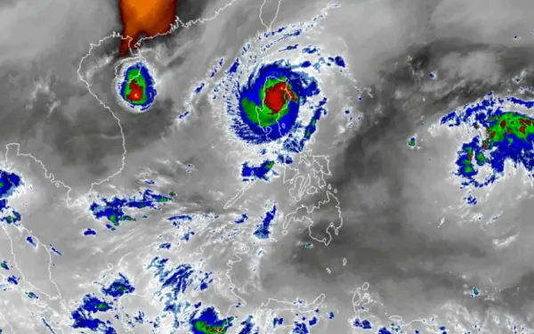
A third cyclone named Man-yi was spotted east of Guam on Monday. It may enter the PAR before the weekend and will be given the local name Pepito.
Pepito may head towards Bicol or Eastern Visayas, PAGASA said.
Experts explained that the occurrence of storms and typhoons at very short intervals was not new and had been monitored as early as the 1950s.
Ana Liza Solis, PAGASA’s Chief of Climatology Monitoring and Prediction Section, explained that the country was in a La Niña-like condition where sea surface temperatures in the Eastern Pacific Ocean are much cooler than warmer temperatures in the western section. These warmer sea surface temperatures make it favorable for water evaporation and cloud formation, which later result in tropical depressions and storms or even typhoons, she said.
“When the winds caused by the amihan enter, it is possible that the typhoon will avoid it. This means that there is a possibility that the track of the typhoon will change when the northeast monsoon or amihan enters,” she said.
rtheast monsoon season yet but says it may “just be around the corner.”
NIKA’S ONSLAUGHT
On Monday, rescuers said around 7,000 people were moved from coastal areas as well as flood-prone and landslide-prone areas in Aurora and Isabela, the first two provinces to be struck before Nika plowed inland to the mountainous interior of the main island of Luzon.
"We're getting hit with strong winds and heavy rain. Some trees are being toppled and power has been cut since yesterday," Merwina Pableo, civil defense chief of Dinalungan town near Dilasag, told AFP.
cannot go out yet to make a damage assessment."In all, the government ordered 2,500 villages to be evacuated on Sunday, though the national disaster office does not have the total number of evacuees as of Monday.
In the landfall area of Dilasag, Aurora, school teacher Glenn Balanag, 31, filmed the onslaught of the howling 130 kilometers an hour winds, which violently shook coconut trees around his rural home.
"Big trees are falling and we heard the roofs of some houses were damaged. The rain is continuing and a river nearby is rising," he told AFP.
The national weather agency warned of severe winds and "intense to torrential" rainfall exceeding 200 millimeters (eight inches) across the north of the country, along with a "moderate to high risk of a storm surge" -- giant waves up to three meters high on the north coast.
Nearly 700 passengers were stranded at ports, according to a coast guard tally on Monday, with the weather service warning that "sea travel is risky for all types or tonnage of vessels".
"All mariners must remain in port or, if underway, seek shelter or safe harbor as soon as possible until winds and waves subside," it added.
Aurora and Isabela officials said the main impact appeared to be downed trees and power pylons that blocked major roads.
"I don't want to send people out yet to investigate. I do not want them to be caught out by powerful gusts," said Constante Foronda, Isabela's disaster response chief.
GREATER CAUTION NEEDED
Chris Perez, PAGASA senior weather specialist, explainsED the severity of rainfall could have varying effects depending on where it happens. This means that intense to torrential rainfall will not always have the same impact in every locality.
"For example, if a typhoon drops 200 millimeters of rain in Metro Manila, which is highly urbanized, it will really flood. If that 200 millimeters of rain falls in rural areas, the impact will not be as immediate," he said.
(For instance 200 millimeters of rain pouring in Metro Manila, a highly urbanized area, will definitely result in flooding. But the same amount of rain, if it happens in a rural area, will not have the same impact.)
The series of typhoons that has battered the country, particularly Luzon, the past couple of months calls for extreme caution to be exercised especially for those living in landslide-prone areas.
The weather systems outside PAR may just make it worse.
"Given these projections that the two upcoming typhoons are roughly also possible to pass through there, then definitely its impact will multiply given that the land is saturated," he said.
“Given that the projections of the two new typhoons show roughly the same track as of previous typhoons, it will definitely multiply potential impacts,” Villafuerte said.
Experts call on the public to remain alert by keeping updated with latest rain, flood and weather advisories, as well as heed the advice of local governments to keep themselves safe amid extreme weather.
PNP ON HEIGHTENED ALERT
All police regional offices have been placed on heightened alert for Typhoon Nika and the two other succeeding cyclone, a police official said Monday.
Philippine National Police spokesperson BGen. Jean Fajardo said police were helping with the pre-emptive evacuation, particularly in northern Luzon.
The Reactionary Standby Support Force (RSSF) has also been activated to bolster the police force and possibly lead incident management and disaster response.
Interior Secretary Jonvic Remulla earlier said the soil in cyclone-hit areas was saturated and the risk of landslides was high.
"There is also a directive sent by the DILG, our secretary, for all PROs to coordinate with their respective LDRRMC and LGU to prepare here in Nika, and even Ofel, and even Pepito," Fajardo said.
Nika came on the heels of three cyclones in less than a month that killed 159 people.
On Thursday, Typhoon Marce slammed into the country's north coast, damaging houses and buildings.
A 12-year-old girl was crushed to death in one incident.
Before that, Severe Tropical Storm Kristine and Super Typhoon Leon together left 158 people dead, the national disaster agency said, with most of that tally attributed to Trami.
About 20 big storms and typhoons hit the archipelago nation or its surrounding waters each year.
A recent study showed that storms in the Asia-Pacific region are increasingly forming closer to coastlines, intensifying more rapidly and lasting longer over land due to climate change.